Google, partners unveil first AI-powered FireSat satellite to spot wildfires in minutes

Google, in a collaborative effort with its artificial intelligence technology partners, has launched the first satellite in the innovative FireSat constellation, set to revolutionise wildfire detection and response.
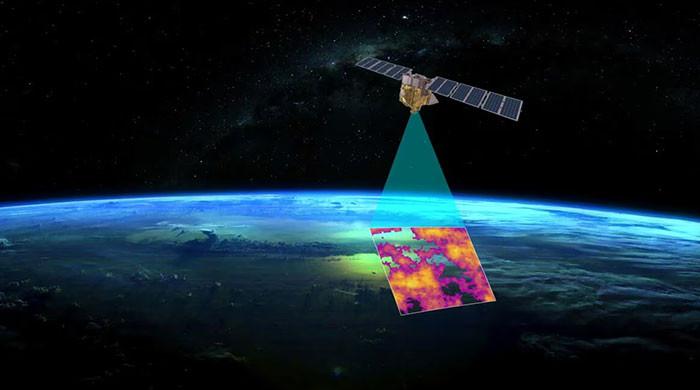
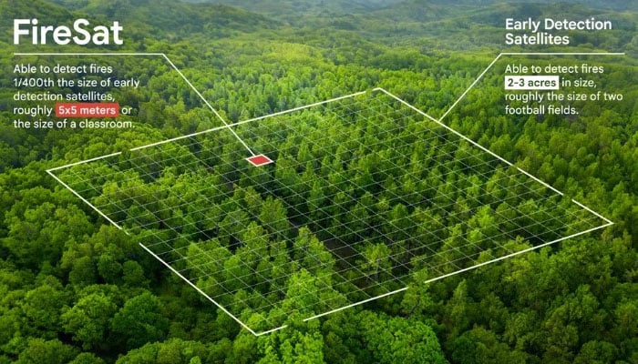
This FireSat satellite intitiative, a collaboration among Google Research, Muon Space, Earth Fire Alliance, Moore Foundation, and global wildfire authorities, boasts the capability to identify wildfires as small as 5×5 metres within just 20 minutes, ESG News reported.
The tech giant invested $13 million in this project through its ‘AI Collaborative: Wildfires’ initiative.
Unlike traditional methods that rely on infrequent, low-resolution satellite images, which often result in delayed responses, FireSat provides near real-time data to firefighting authorities.
This advancement siginificantly enhances response capabilities, underscoring the urgent need for rapid detection highlighted by Juliet Rothenberg, who experienced a California wildfire evacuation first-hand.
“All we received was updated satellite imagery every 12 hours, while throughout the Bay Area, the sky was red and full of smoke. But what was even more shocking was realising that wildfire authorities didn’t have much better data than we did,” said Rothenberg.
The first of 50 satellites was launched from Vandenberg Space Force Base.
The choice of utilise satellites over high-altitude drones in wildfire monitoring is largely attributed to falling satellite costs and their ability to oversee remote mountainous areas where fire frequently ignite.
Meanwhile, Chris Van Arsdale, co-founder and part of the FireSat team, said that the team faced several challenges to bring the innovation to life.
He said: “Differentiating between real fires and random ‘noise’ in the environment was a challenge. We had to determine where to draw the line between what is a real fire versus things like sensor issues or misaligned pixels.”
FireSat’s early detection capabilities may potentially help curb economic and humanitarian losses from wildfires and while bolstering protection for vulnerable communities and ecosystems worldwide.
Additionally, FireSat’s data will establish a global historical record of fire behaviour, helping scientists in predicting future wildfires.
“FireSat is more than just an emergency response tool,” said Rothenberg. “It’s also an incredible tool for reducing greenhouse gas emissions. It’s actually really beautiful that the constellation contributes to reducing climate change — while also responding to it.”